Goods in action
Need help choosing,
advice on transport or payment?
Use the chat or contact form.
We will be happy to help you.
We deliver throughout the European Union.


| List Number: | 01927 |
| EAN: | 9771213819130 |
| Warranty: | |
| Manufacturer: | GeoBohemia |
| Price excluding VAT: | 1,83 € |
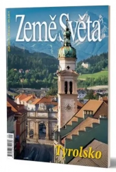
Tyrol lies in the heart of the Austrian Alps, wedged between Germany, Switzerland and Italy. Its river axis is formed by the milky green glacial Inn. Thanks to its natural beauty, Tyrol is one of the most visited regions of the Republic of Austria. It has excellent conditions for summer alpine tourism and winter sports – five glaciers allow skiing all year round. After all, the city of Innsbruck has already hosted the Winter Olympics twice.
After Lower Austria and Styria, Tyrol is the third largest of Austria's nine federal states (12,647 km2), its population of just over 700,000 places it in fifth place, but it has the longest state border (719 km). It's especially interesting with those here. A look at the map reveals that today's federal state consists of two territorially separate parts - North Tyrol (Nordtirol) and East Tyrol (Osttirol). They are separated from the north by Salzburg and from the south by the tip of Italy. This arrangement has been valid since 1919. The territory to which this promontory belongs is called South Tyrol (Südtirol, Italian Alto Adige) and until the end of the First World War it was part of of historical Tyrol, divided only by the Treaty of St. Germain between Austria and Italy. A separate issue of Countries of the World (4/2008) was dedicated to South Tyrol. If not for the violent division, Tyrol would have been Austria's largest federal state. However, even in today's "trimmed" form, it still has a lot to offer visitors.


